Four Countries in a Day
447 km from a Maastricht filling station to a Valkenburg restaurant table — Belgian Limburg, the Eifel dams, the Luxembourg Ardennes and Belgium's highest ground, with 5,735 metres of climbing in between.
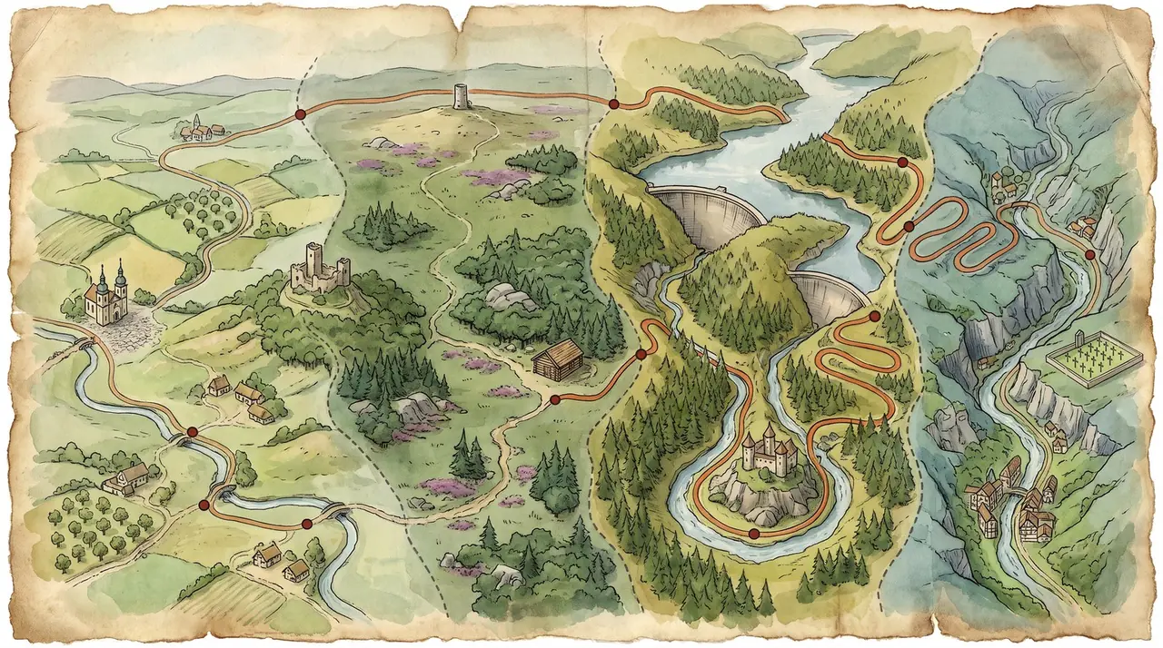
447 km, four countries, one very long and very good day
Out of Maastricht early, head over the border into Belgian Limburg before the first coffee, then into the German Eifel for the dam lakes and the Biker Ranch. Head south to Prüm for lunch, head across into Luxembourg for the twistiest hour of the day, then head back north into Belgium over the Hautes Fagnes and up into Valkenburg as the sun sets. This is not a route you squeeze into an afternoon. Give it the whole day and it gives you four countries back.
"Four border crossings, two dam walls, the best-known bikers' cabin in the Eifel and an hour of Luxembourg hairpins. Then a spa town waiting at the end of it."
— Alan Jones, on Four Countries in a DayElevation profile
How it rides
Four hundred and forty-seven kilometres, four countries, and 5,735 metres of climbing. On paper that is a big day. In practice it is bigger, because almost none of this is fast road. It is second and third gear country: river gorges, dam walls, forest ridges, moorland plateau and one long stretch of Luxembourg hairpins where you will not see a straight for twenty minutes at a time.
The satnav says seven and a half hours of moving time. Add the stops you will actually want — coffee, a proper lunch, two fuel halts and the odd photograph — and you are looking at nine to ten hours door to door. Leave Maastricht early — eight in the morning is not too soon. Anything later and you will be pushing through the last hundred kilometres in fading light with a tired right wrist, which is exactly when the Hautes Fagnes stops being fun.
Ride it between April and October. In winter the high ground above Malmedy and Monschau gets fog, ice and salt, and the shoreline roads collect wet leaves.
Leg one — Maastricht to the Belgian border, km 0–20
The start is deliberately unromantic: the filling station on Dr Schaepmanstraat on Maastricht's east side, a few hundred metres from MVV's De Geusselt stadium. Fill the tank to the neck. Fuel is noticeably cheaper the moment you cross into Belgium, but you want to begin the day with a full tank rather than hunting for one.
Out through Borgharen, over the Maas and the border comes and goes without ceremony. Within twenty kilometres you are in Belgian Limburg and the road has already begun to climb.
Leg two — the Vesdre valley and Limbourg, km 20–50
This is the warm-up, and it is a good one. Froidthier, Goé and the climb to Limbourg at km 39, where the old town sits on a spur of rock above the Vesdre with a cobbled square on top. The way in is steep and tight. The way out is better.
Just south of here, about two kilometres off the line, is the Barrage de la Gileppe — an arch-gravity dam built between 1868 and 1878, inaugurated by Leopold II, and raised by another sixteen metres in the early seventies. If you have time in hand it is worth the detour for the giant stone lion on the crest.
The route runs on through Membach and Eupen and crosses into Germany at around the fifty-kilometre mark, climbing hard as it goes.
Leg three — the Eifel dams and the Biker Ranch, km 50–120
Now it gets serious. The road lifts onto the Eifel at over 600 metres and drops into Monschau at km 63, a town of slate-panelled and half-timbered houses jammed into the Rur gorge, with more than 330 listed buildings and streets that have barely changed in three centuries. It sits about a kilometre off the track — take the detour, it costs you five minutes.
At km 74 the route passes the front door of the Biker Ranch at Simmerath-Strauch. A log cabin on the roundabout at Monschauer Strasse 66, stacked tyres along the terrace, Bitburger on the pumps, and on a decent Sunday a car park full of everything from R1s to Guzzis. It is the obvious first stop of the day and the last cheap coffee before Germany's dam country.
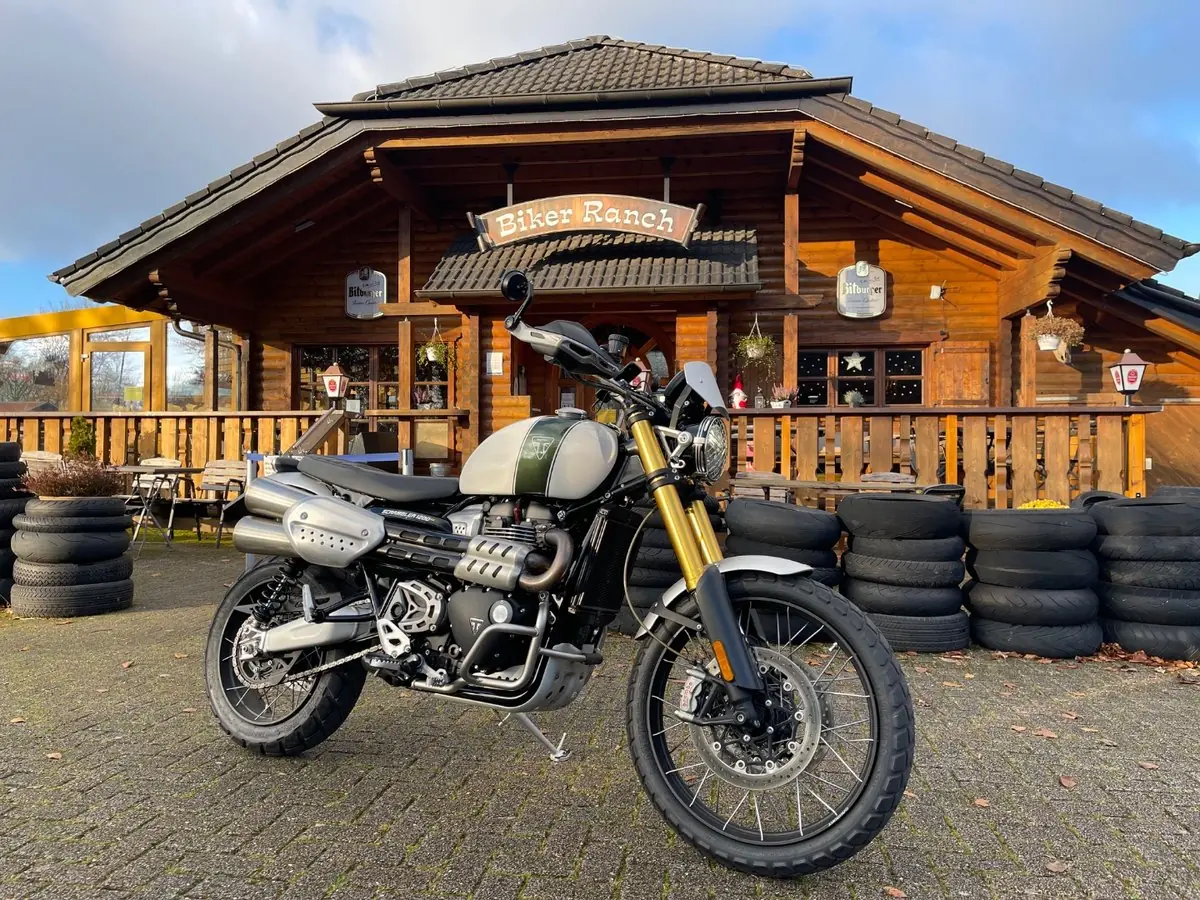
The Biker Ranch at Simmerath-Strauch — km 74, and the route goes past the door.
From there the ride threads the reservoirs. The Rurtalsperre Schwammenauel at km 89 is the big one: a 77-metre earth and stone wall built between 1934 and 1938, raised by another twenty metres in the fifties, holding back a lake of 7.8 square kilometres. In February 1945 the Germans opened its sluices to flood the Roer valley and stalled the American Ninth Army for a fortnight. The road drops to the crest and climbs straight back out again.
A little further on, at km 93, the Urfttalsperre is the elder statesman — 1900 to 1905, 58.5 metres of quarried greywacke and slate, with a spillway that cascades down thirty-three steps. It sits inside the Eifel National Park, about a kilometre and a half off route. The Ordensburg Vogelsang, the former Nazi elite school now open as a documentation centre, is roughly four kilometres off the line above the Urftsee if you want to make a morning of it.
Then Gemünd, Schleiden and Olef, and the long haul south across the high Eifel towards the Rhineland-Palatinate border.
Leg four — lunch at Prüm, km 120–170
Km 169, and this is your lunch stop. Prüm sits in the Westeifel below the Schneifel ridge, and the whole town is arranged around the square in front of the Salvatorbasilika: two tall dark spires, a broad pink baroque front, and enough space to park a row of bikes and look at it properly. The abbey was founded in 721 and its church was consecrated by Pope Leo III in 799, which makes it older than almost anything else you will pass all day. Ninety-two per cent of the town was destroyed in the Second World War, and then wrecked again in 1949 by an ammunition explosion on the Kalvarienberg — so what you are looking at is largely a rebuild, and a good one.
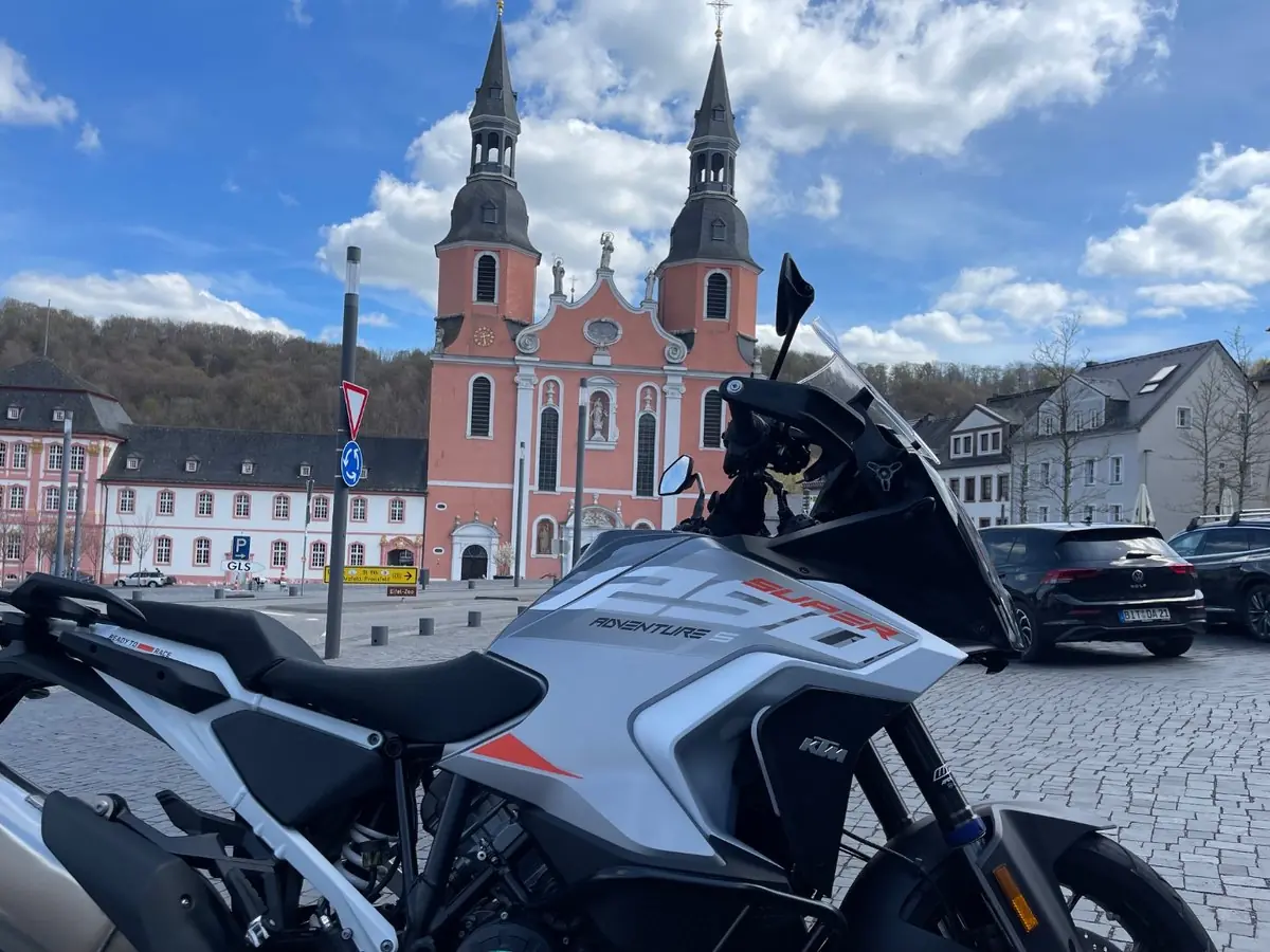
Lunch at Prüm. The Salvatorbasilika does the rest of the work.
Take a full hour here. You are halfway, you have the twistiest part of the day still ahead of you, and eating properly now is the difference between enjoying Luxembourg and merely surviving it. Fill up before you leave — German fuel is cheaper than Belgian and there is no guarantee of a convenient pump in the Our valley.
Leg five — into Luxembourg, km 170–300
South through Pronsfeld and Waxweiler, then the descent to Dasburg at km 213 where the road crosses the Our and you are in Luxembourg. This is the best hour of the ride.
The road climbs out of the Our to Dorscheid, then works its way down through Bockholtz, Wilwerwiltz and Kautenbach in the deep slate valleys of the Luxembourg Ardennes. Tight, blind, beautifully surfaced, and almost empty on a weekday. Watch for gravel washed onto the apexes after rain.
At km 255 the route reaches Esch-sur-Sûre, and if you only remember one village from this ride it will be this one. The Sûre loops almost the whole way round a rocky spur, the ruined castle sits on top of it, and the road tunnels through the rock to get in. Two kilometres later comes the dam that created the Lac de la Haute-Sûre — Luxembourg's largest body of water, engineered by André Coyne, first flooded in 1959, forty-three metres deep with forty-eight kilometres of shoreline. The lakeside roads through Lieffrange, Bavigne and Boulaide rise and fall constantly and are a genuine pleasure.
North through Mecher and Grümelscheid, and at around km 300 you are back in Belgium near Bourcy, a few kilometres north-east of Bastogne.
Leg six — East Belgium and the Hautes Fagnes, km 300–400
Sankt Vith at km 348 is your second fuel and coffee stop, and it is a good one to take — you have ninety-odd kilometres of hard riding left. The town was a market centre by the twelfth century and held town rights from 1350, then was bombed flat over Christmas 1944 during the Battle of the Bulge. The Büchel Tower is the only pre-war building left standing.
From Born and Géromont the road runs down to Malmedy at km 374, an abbey town founded in 648 and sitting at the lowest point of the return leg. Enjoy it, because immediately afterwards comes the last big climb of the day.
The route lifts onto the Hautes Fagnes — the High Fens, Belgium's largest nature reserve since 1957, forty-five square kilometres of peat bog and moorland. At km 386 you pass within a kilometre of Signal de Botrange, at 694 metres the highest point in Belgium, in the Ardennes, and in the whole European Benelux. There is a café at the top and a six-metre tower built in 1923 so visitors could stand at a round 700 metres. The route's own high point, 678 metres, comes two kilometres later, and then Baraque Michel at km 393.
This is exposed, open ground. It can be twenty degrees in Malmedy and blowing horizontal drizzle up here, and it is the single most likely place on the whole route to catch you out.
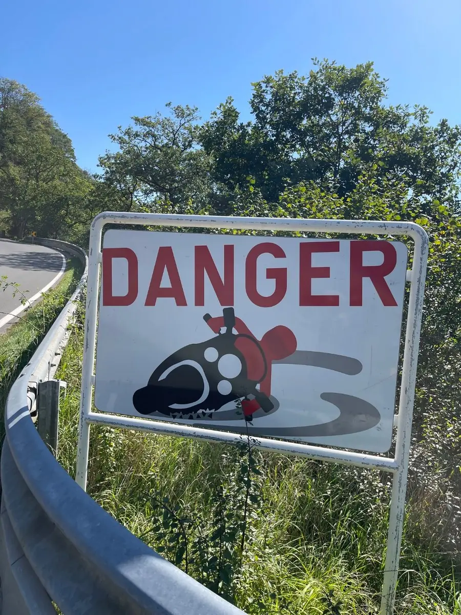
These signs are not decoration. Where you see one, somebody has already got it wrong.
Down through Membach and Walhorn, past Eupen for the second time in the day at km 403, and the temperature comes back up as the road drops.
Leg seven — home into the Heuvelland, km 400–447
Hombourg, Teuven and back across into Dutch Limburg at km 430. The last stretch is familiar Heuvelland country: hollow lanes, orchards and gentle ridges, a relief after nine hours of hard work.
At km 439 the route passes the Netherlands American Cemetery at Margraten — twenty-six and a half hectares, more than eight thousand American graves and the names of 1,722 missing, begun in November 1944 and officially opened by Queen Juliana in 1960. It is the only American cemetery in the Netherlands. Stop, even if your legs are done.
Then Sibbe and the drop into Valkenburg aan de Geul at km 447. It is a good place to end a long day: the castle ruins above the town, the marl caves under it, Thermae 2000 up on the Cauberg with thermal water drawn from 381 metres down, the casino, and a centre packed with restaurants and terraces. Park the bike, get the boots off, and have the beer you have been thinking about since Prüm.
What's in the GPX
The file is a GPX 1.1 track built in Kurviger, with fourteen named waypoints embedded. Load it into Kurviger, Garmin, TomTom, Calimoto, OsmAnd or Scenic and the stops below will appear on the map with a short note attached to each.
| # | Waypoint | Why stop |
|---|---|---|
| 1 | Maastricht — De Geusselt | Start — filling station on Dr Schaepmanstraat, by the stadium |
| 2 | Limbourg | Cobbled hilltop square above the Vesdre — km 39 |
| 3 | Monschau | Slate gorge town, 330+ listed buildings — km 63 |
| 4 | Biker Ranch, Simmerath | The Eifel's bikers' cabin, right on the route — km 74 |
| 5 | Rurtalsperre Schwammenauel | 77 m dam wall holding the Rursee — km 89 |
| 6 | Urfttalsperre | The older dam, 1905, inside the Eifel National Park — km 93 |
| 7 | Prüm — Salvatorbasilika | Lunch — twin-towered abbey church on the square, km 169 |
| 8 | Esch-sur-Sûre | Castle ruin inside a horseshoe river bend — km 255 |
| 9 | Lac de la Haute-Sûre | Luxembourg's largest lake, 48 km of shoreline — km 257 |
| 10 | Sankt Vith | Fuel and coffee in East Belgium — km 348 |
| 11 | Malmedy | Abbey town at the foot of the last big climb — km 374 |
| 12 | Signal de Botrange | Belgium's highest point, 694 m — km 386 |
| 13 | American Cemetery, Margraten | 8,000 graves and 1,722 names of the missing — km 439 |
| 14 | Valkenburg aan de Geul | Finish — hilltop spa, casino and a street full of restaurants |
Practical notes
Start early. Eight in the morning, tank full, breakfast eaten. This is the one piece of advice that matters most.
Timings. Seven and a half hours of moving time is the mapping figure and it is realistic if you keep a decent pace. Budget a minimum of an hour and a half on top for food and fuel — an hour at Prüm and two half-hour halts — which puts the day at nine hours. Add a bit more if you like photographs. Ten hours door to door is a comfortable, honest plan.
Fuel. Fill up in Maastricht before you go, then again in Prüm at the halfway point and at Sankt Vith at km 348. German and Luxembourg fuel is cheaper than Belgian, and Belgian cheaper than Dutch. There are long stretches in the Our valley and on the Fens with nothing open, especially on Sundays.
Four sets of rules. Speed limits change with every border, and so does the enforcement. Belgian and Luxembourg limits on secondary roads drop to 70 and 90 respectively; German Landstrassen are 100 unless posted otherwise. Dutch and Belgian towns are 30 or 50 and heavily camera-ed. Carry your documents.
Noise controls in Germany. The Eifel is popular with bikers and the police know it. Roadside checks on loud exhausts are common at weekends, particularly around the lakes and the well-known biker roads. If your can is not road legal, this is not the day to find out.
Roads closed to motorcycles. Germany closes certain roads to bikes, sometimes only at weekends or on public holidays. These closures are not in the GPX and they change from season to season, so watch for the signs and be ready to take the detour rather than argue about it.
Weather. The Eifel and the Hautes Fagnes make their own conditions. Take a waterproof layer even on a forecast blue day, and check the temperature at Botrange rather than at your kitchen window — it is routinely five to eight degrees colder up there.
Surfaces. All paved and mostly excellent, but the Luxembourg valley roads and the Rursee shoreline collect gravel, mud off tractors and wet leaves. Slow into blind bends. The roadside crash-warning signs on these roads are there for a reason.
If you want to shorten it. The natural split is Prüm: stay the night there or in Sankt Vith and ride it as two half-days. The Luxembourg section from Dasburg to Boulaide is the part to keep if you have to cut something.